Tools for Monitoring and Verification
-
North Australia Fire Information
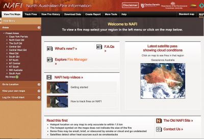
North Australia Fire Information (NAFI) is an essential tool used by fire managers implementing indigenous savanna burning projects. The data it provides both supports fire planning, and assists the projects meet regulatory requirements by recording where and to what extent early dry season burning has taken place.
The NAFI site displays maps of fire activity based on information from satellites, such as hotspots (locations of recently burning fires) and fire scars (maps of recently burnt country). The maps are displayed to meet the needs of north Australian and remote area fire managers.
Hotspots are sourced from various satellites. Firescars are sourced from the Darwin Centre for Bushfires Research at Charles Darwin University(for NT and northern WA fire scars) and from Cape York Peninsula Sustainable Futures (for Queensland).
The site has been funded directly by the Federal Government and through Territory NRM. The site is hosted at Charles Darwin University.
For early dry season burning, NAFI reports that early dry season fires are difficult to accurately map even at the 250m MODIS scale. The ability for NAFI mapping to identify smaller and cooler early dry season burnt areas more readily than other available burnt area mapping products is important as they are often significant for operational planning purposes.
Small burnt areas and early dry season fires form important strategic fire breaks. Indeed fire breaks produced from aerial incendiary operations are often quite small in the early dry season as ground fuel moisture is high enough to resist pyrolysis, often extinguishing fires overnight.
The ability for land managers to provide input into the NAFI mapping process through providing ancillary data such as burn lines and or direct field based feedback on return visits to burnt areas builds a sense of participation in the product. This collaborative aspect of NAFI this has helped to build user confidence in the product and has resulted in it becoming the default fire management web service across northern Australia.
NAFI also hosts the SavBAT2 tool, developed to assist eligible projects and prospective projects calculate emissions abatement potential.
Further resources:
